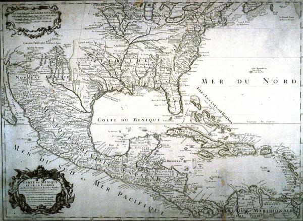
Carte du Mexique et de la Floride
Colonial Louisiana, Caribbean, Gulf of Mexico, Central America, Mississippi River
Deslisle, Guillaume
Paris
File includes B + W photograph and negative. Based largely on information provided by Iberville, is first map to depict with any degree of accuracy, the course of the Mississippi River (except Hennepin's) and to show many of its western tributaries. Spanish settlements along the Rio Grande shown, as well as Zuni Indian pueblos of southern Arizona; one of the earliest mentions of the Colorado River. Mother map of Louisiana copied by cartographers for over 100 years. See label above, and note that the figures in the cartouche were reversed, and then included, in John Senex's 1710 map of North America seen in the 1996 exhibition.
Foundation map of Louisiana. First map to depict with a large degree of accuracy the course and mouth of the Mississippi River from its mouth to the Falls of St. Anthony in present-day Minnesota. The area shown extends from the northern coast of South America to the Great lakes and from New England to, and including, New Mexico. This map greatly influenced subsequent European mapmakers in their delineation of the Mississippi Valley, and, to a lesser extent, the southeastern region. Although the map cites Guillaume Deslisle as the cartographer, many experts believe his father Claude served as cartographer. Deslisle used the latest journals and reports from the French explorer Pierre le Moyne d'Iberville's and those who accompanied hi. The two figures flanking either side of the cartouche are personifications of the Old and New Worlds. Europe, the male figure on the right pointing to America, is surrounded by standard symbols of Europe: the winged dragon at his feet, Hercules's club used to wound th4 Nemeon lion, and a bow constructed in the four-curved manner, a style common to Europe. An alligator lies at the feet of America, the female figure to the left. She holds a parasol in her left hand, another customary symbol Of America, while a putto peeks from behind her right shoulder.