New Map of the River Mississipi [sic] from the Sea to Bayagoulas, A
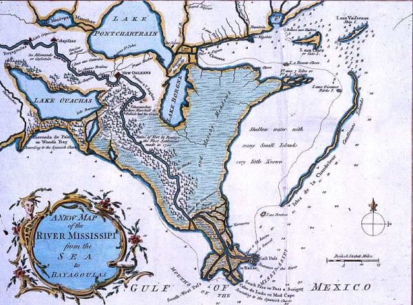
Mississippi delta; les Cannes Bruslees; Bayou du Mardi Gras; ruins of Fort la Boulaye; Tchaouachas where Marshall de Bellisle had his grant; location of Indian tribes: Colapissas, Bayagoulas, Houmas. Fort La Boulaye, Mississippi Fort, Phoenix, Louisiana, Plaquemines Parish.
London magazine
[London]
Other copies located 1997.078.003, 1980.065.007 (photographed); other copies, not as good condition 03136b, 12830.001. Nicely colored; Label from 1996 exhibit: The "Bayagoulas" were Indians living near the present-day town of Bayou Goula, Louisiana, in Iberville Parish. Their name was derived from the Choctaw or Mobilian language meaning "bayou people." Soon after the French arrived in Louisiana the Bayougoulas and other Muskogean-speaking peoples lost their separate identities and were defined by Europeans as "Colapissas," who eventually became known as the Houma Indians. Another important feature of this map is the depiction of Fort La Boulaye, located on the right bank of the Mississippi River about fifty miles from the Gulf of Mexico. On February 3, 1700, Pierre Le Moyne d'Iberville and his brother Bienville met at this site and established Fort La Boulaye, the first European settlement in what is now Louisiana. Sometimes referred to as the Mississippi Fort, it was abandoned about seven years later. In 1933 the remains of Fort La Boulaye were discovered near present-day Phoenix, Louisiana, in Plaquemines Parish.
The "Bayagoulas" were Indians living near the present-day town of Bayou Goula, Louisiana, in Iberville Parish. Their name was derived from the Choctaw or Mobilian language meaning "bayou people." Soon after the French arrived in Louisiana the Bayougoulas and other Muskogean-speaking peoples lost their separate identities and were defined by Europeans as "Colapissas," who eventually became known as the Houma Indians. Another important feature of this map is the depiction of Fort La Boulaye, located on the right bank of the Mississippi River about fifty miles from the Gulf of Mexico. On February 3, 1700, Pierre Le Moyne d'Iberville and his brother Bienville met at this site and established Fort La Boulaye, the first European settlement in what is now Louisiana. Sometimes referred to as the Mississippi Fort, it was abandoned about seven years later. In 1933 the remains of Fort La Boulaye were discovered near present-day Phoenix, Louisiana, in Plaquemines Parish.