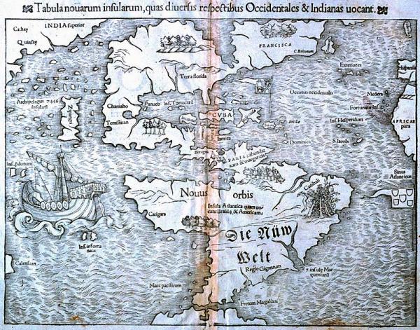
Tabula novarum insularum, quas diversis respectibus Occidentales & Indians vocant
New World, North and South America, cannibalism
[Münster, Sebastian]
Basle
First separate map of the Americas. Leen Helmink offered a "rare and sought after state from 1552 edition" published in Basle in the "Cosmographica" atlas, titled "Novae Insulae XXVI Nova Tabula." See map folder.
From Münster's "Cosmography." This is a second state of his earlier woodblock engraving, "Novae Insulae," first published in 1538. It is the earliest known depiction of only North and South America as two land masses joined together, and distinct from other continents. Versions of this map appeared in Latin, French, and other languages, but on this German edition only the name "Die Nüw Weldt (the New World) has been translated. By implication, North America is divided between France ("Francisca") to the north, and Spain ("terra Florida") to the south. Portugal's flag flies just off the African coast.
Giovanni da Verrazano's accounts of the new World provided much of the cartographic detail included in this map, while the West Coast geography was taken from Marco Polo's description of Eastern Asia. Japan, here named "Zipangri," is placed just off the west coast of North America.
Decorative elements adorning maps during the age of exploration reflected Old World assumptions regarding the nature of New World inhabitants. An engraver's ornamentation choice often determined the public's notion of other peoples. Cannibalistic South Americans are depicted here in the area of Brazil; just beneath this cartouche is an area labeled "Region of Giants" ("Regio Gigantum.")
A large ship in the Pacific, usually identified as that of Magellan, bears little resemblance to late fifteenth-century sailing vessels. Magellan's "Victoria" probably had three masts but Münster's picture is of a single-masted type more typical of ships plying Northern European waters during the fourteenth century. The northern coast of South America bears the legend "abundae auro ac margaritis" (abundant gold and pearls.)
The isthmus of North Carolina, the result of Verrazano's miscomprehension of the Outer Banks of North Carolina, is also depicted on this map.