Carte de la Louisiane et du Cours du Mississipi (sic)
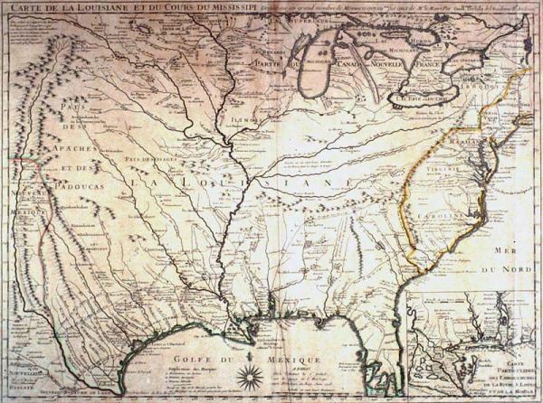
Colonial Louisiana; first detailed map of the Gulf region and the Mississippi River, first printed map to show Texas (Mission de los Teijas), earlier land routes. Copied by many European mapmakers; nearly correct delineation of Mississippi River; and location of Appalachian, Ozark, Rocky Mountains; mineral resources; location of many Indian tribes.
Deslisle, Guillaume
[Paris]
For first state, no New Orleans, see 1982.077.158. Second copy of second edition located 1978.022. Facsimile copy, second state, located 02020. Label from 1996 show: During the preparation of the copperplate for the first edition of this map (which did not show New Orleans), Deslisle relied upon information forwarded to him by French explorers in Louisiana. Although Jean Baptiste Le Moyne, Sieur de Bienville (1680-1767), founded New Orleans before Deslisle prepared the copperplate for this map, Bienville was slow in sending the location of the fledgling settlement to Deslisle. Although he began printing this map I June 1718 without location New Orleans, when he was advised (possibly in Fall 1718 or Spring 1719) of its founding he engraved the name Nouvelle Orleans at the site and resumed printing copies of this map. Thus, there are two editions of the "Carte de la Louisiane" dated June 1718 --one that includes the Crescent City and one that does not.
10/19/84 - ? : Corcoran Gallery for Sun King Exhibition
Dec 1982-1984: map exhibition in Presbytere.
8/81 - 1/82: Acadian Textile exhibit, Museum of Natural History, Lafayette, La.
Second state, showing New Orleans. During the preparation of the copperplate for the first edition of this map (which did not show New Orleans), Deslisle relied upon information forwarded to him by French explorers in Louisiana. Although Jean Baptiste Le Moyne, Sieur de Bienville (1680-1767), founded New Orleans before Deslisle prepared the copperplate for this map, Bienville was slow in sending the location of the fledgling settlement to Deslisle. Although he began printing this map I June 1718 without location New Orleans, when he was advised (possibly in Fall 1718 or Spring 1719) of its founding he engraved the name Nouvelle Orleans at the site and resumed printing copies of this map. Thus, there are two editions of this foundation (or "mother") map dated June 1718 --one that includes the Crescent City and one that does not.
TThis is a foundation or "mother" map of colonial Louisiana. Throughout history, certain maps which, because of accurate details and incorporation of the results of recent explorations, cartographers call "foundation" or "mother" maps. The influence of foundation maps persisted long after later discoveries and settlements because until the nineteenth century, most mapmakers reproduced their predecessors work.