Carte de la Louisiane et du Cours du Mississipi (sic)
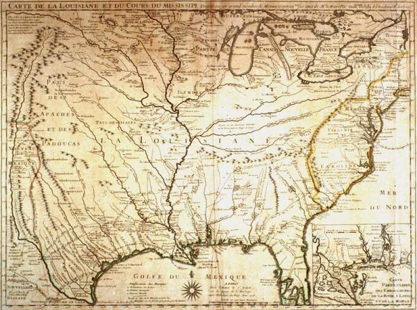
Colonial Louisiana. The original of this map was the first detailed map of the Gulf region and the Mississippi River and the first printed map to show Texas (Mission de los Teijas), earlier land routes. Copied by many European mapmakers; nearly correct delineation of Mississippi River; and location of Appalachian, Ozark, Rocky Mountains; mineral resources; location of many Indian tribes.
Deslisle, Guillaume
Folder includes B + W photograph. B + W negative stored in Registrar's office. Delineates New Orleans. Copies of second state (delineating New Orleans) located 1979.074; 1978.022; first state, no New Orleans, located 1982.077.158. Other facsimiles/non-originals located EC1998.1-5 (c6d9).
Label from 1996 show:
A "war of maps" waged between England and France during the first half of the eighteenth century exemplifies how maps were used by competing Europeans powers to claim territory in the New World. This cartographic confrontation culminated with the French and Indian War (known as the Seven Years' War in Europe), which in turn ended with the expulsion of France from the North American continent.
[this map was] the first "shot" fired in the war of maps [and] features North America from Long Island to the Rio Grande and southward to the lower half of the Florida peninsula. Made by Deslisle for the Company of the West, it had a distinct political purpose: to circumscribe and minimize Britain's western territories [in the New World.] Deslisle characterized "Caroline" as discovered, named, settled, and possessed by France. This map also delineated French claims to the Rio Grande as the boundary line between Louisiana and Spanish Mexico.
The original of this map was a foundation or "mother" map of colonial Louisiana. Throughout history, certain maps which, because of accurate details and incorporation of the results of recent explorations, cartographers call "foundation" or "mother" maps. The influence of foundation maps persisted long after later discoveries and settlements because until the nineteenth century, most mapmakers reproduced their predecessors work.
A "war of maps" waged between England and France during the first half of the eighteenth century exemplifies how maps were used by competing Europeans powers to claim territory in the New World. This cartographic confrontation culminated with the French and Indian War (known as the Seven Years' War in Europe), which in turn ended with the expulsion of France from the North American continent.
This map was the first "shot" fired in the war of maps [and] features North America from Long Island to the Rio Grande and southward to the lower half of the Florida peninsula. Made by Deslisle for the Company of the West, it had a distinct political purpose: to circumscribe and minimize Britiain's western territories [in the New World.] Deslisle characterized "Caroline" as discovered, named, settled, and possessed by France. This map also delineated French claims to the Rio Grande as the boundary line between Louisiana and Spanish Mexico.
During the preparation of the copperplate for the first edition of this map (which did not show New Orleans), Deslisle relied upon information forwarded to him by French explorers in Louisiana. Although Jean Baptiste Le Moyne, Sieur de Bienville (1680-1767), founded New Orleans before Deslisle prepared the copperplate for this map, Bienville was slow in sending the location of the fledgling settlement to Deslisle. Although he began printing this map I June 1718 without location New Orleans, when he was advised (possibly in Fall 1718 or Spring 1719) of its founding he engraved the name Nouvelle Orleans at the site and resumed printing copies of this map. Thus, there are two editions of this map dated June 1718 --one that includes the Crescent City and one that does not.