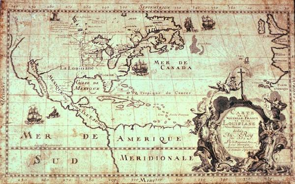
Carte de la Nouvelle France et de la Louisiane Nouvellement decouverte [Map of New France and Louisiana, Newly Discovered]
Colonial Louisiana; Mississippi River; Louis Hennepin
Other copies/editions located 02426 (original); 00340; 1955.002.040; 1997.078.058.
Folder houses a 4 x 5 B & W glossy photograph
From Louis Hennepin's "Description de la Louisiane, nouvellement décoiuverte au Sud'Oüest de la Nouvelle France, " (Paris, 1683.) Religious symbolism dominates the title cartouche of this reproduction of Hennepin's map. Christianity, depicted by an angel, a cross, and an open bible, triumphs over paganism, the falling figure to the left. The reverent faithful appear to the right. The female holding a shield decorated with three "fleurs-de-lis" personifies France.
While René-Robert Cavelier de La Salle explored the lower Mississippi Valley, Louis Hennepin (1640-c.1705), a Recollect priest, traversed the Illinois River territory. He went west with La Salle, but was dispatched to the Illinois area to make friends with local Indian tribes. On his way, he investigated the Mississippi River. After living among the Indians for eight months, Hennepin returned to Paris. His 1683 book about the expedition, "Description de la Louisiana Nouvellement Découverte au Sud-Ouest de la Nouvelle France," included this map, which is believed to be the first printed map, made from on-the-spot observations, bearing the name "Louisiane. Because he did not actually descend the Mississippi River to its delta, Hennepin depicted the river "Colbert" [Mississippi River] straight south and with a dotted line continued it to the Gulf at almost the same spot where the mouth empties into the Gulf of Mexico today. When his superiors ordered Hennepin to return to America, he refused and subsequently pledged his allegiance and dedicated a revised edition of his earlier work to King William III of England. In this version, Hennepin described himself as a leader of the expedition. He claimed he traveled the entire three-thousand-mile length of the Mississippi River in forty-seven days (to its mouth and back) two years before La Salle. To support his contention, Hennepin included a map depicting the entire course of the Mississippi River to the Gulf of Mexico. This work received great attention because its author urged William III, and thus England, rather than France, to colonize the Mississippi Valley. The British soon came to realize the economic and political potential of the vast territory described in Hennepin's work. The exaggerated and often fictional account of Hennepin's adventures was among the most widely read books of the period and was subsequently translated into several languages. Thomas Jefferson owned copies of Hennepin's publications, and used them while preparing his 1803 work, "An Account of Louisiana."