Carte de la Nouvelle France ou se voit le cours des Grandes Rivieres de S. Laurens & de Mississipi Aujour d'hui S. Louis [Map of New France Showing the Course of the Great Rivers St. Lawrence and Missisippi, today the St. Louis]
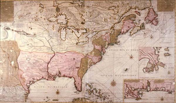
[In the Vicinity of Which Are Found the States, Lands, Nations, Peoples as well as Those of Florida, Louisiana, Virginia, Maryland, Pennsylvania, New Jersey, New York, New England, Acadia, Canada, Eskimos, Iroquois, Illinois, Etc. and of Newfoundland: Drawn from the latest reports received for the establishment of the Company of the West]
Colonial Louisiana, North America, location of Indian tribes, Florida, Virginia, Maryland, Pannsylvania, New Jersey, New York, New England, Acadia, Canada, Eskimo, Hurons, Iroquois, Illinois, Company of the West, Mississippi River delta, St. Lawrence River, Newfoundland, Mobile, Pascagoula, Bay of Ascension, St. Joseph.
Keulen, Gerard van
Amsterdam
Other copy, not as good condition, located T0199.1973. Label from 1996 exhibit: Relying heavily on Deslisle's 1718 "Carte de la Louisiane," van Keulen omitted New Orleans (or did not yet have information concerning its founding), did not include de Soto's route, and added the location of many Indian tribes. The Dutch mapmaker delineated all of New England and much of Canada and depicted Florida as a complete peninsula--unlike Deslisle, who identified the area as an archipelago, a common error of early European mapmakers. This map includes the legend, see to the west of the Mississipp0i River, "land filled with herds of wild buffalo ["pays remoli de troupeaux de Bouefs Sauvages]."
2. Inkomen van de Rivier van Missisipi anders genaant Riv, van St. Louis int Groot
Relying heavily on Deslisle's 1718 "Carte de la Louisiane," van Keulen omitted New Orleans (or did not yet have information concerning its founding), did not include de Soto's route, and added the location of many Indian tribes. The Dutch mapmaker delineated all of New England and much of Canada and depicted Florida as a complete peninsula--unlike Deslisle, who identified the area as an archipelago, a common error of early European mapmakers. The mouth and course of the Mississippi River is generally correct, but the coast of Texas is based on older maps with the bays generally larger than they really are. Delineated with pro-French bias, thereby diminishing British claims in North America. Louisiana extends east to the Alleghenies. Colony of Delaware not shown.