Carte de la Rivierre de Mississippi Suivant les Memoires qui ont été fournis par le Sieur de Tauvel et autres Voyageurs de ce Pays [Map of the Mississippi River according to Reports Supplied by Sieur de Tauvel and Other Travelers in this Country]
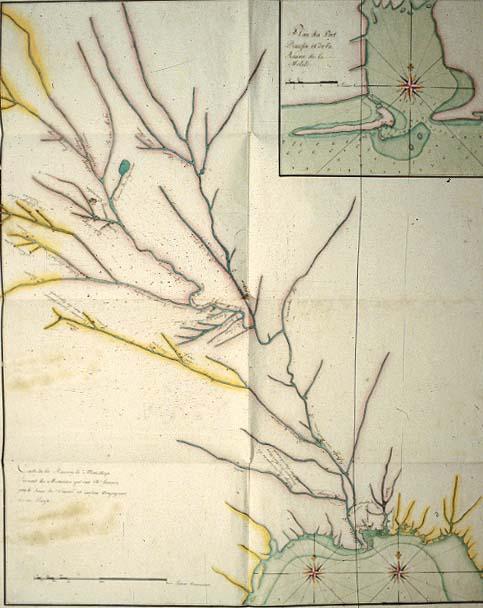
Mississippi River, Mobile Bay, Port Dauphin, location of Indian tribes, "upside down" lettering;
[Paris?]
Letters to France failed to confirm the true maker of this map. Beautifully colored. Label from 1996 exhibition:
This map is stylistically similar to river maps drawn by native peoples. Note that the map is delineated as if one were descending--the more common navigational mode of the seventeenth century--rather than ascending the river. We note that not all maps have lettering oriented for persons travelling south to north, the usual way to mark cartographic place-names.
Although the maker of this map is unidentified, some experts believe it may have been drawn by Guillaume Deslisle, or at his direction, from notes made by Etienne Venyard de Bourgmont (c. 1680-c.1730, a French explorer living among Indian tribes residing along the Missouri River as well as from information provided by the "Sieur de Tauvel" noted in the title.
Although the maker of this map is unidentified, some experts believe it may have been drawn by Guillaume Deslisle, or at his direction, from notes made by Etienne Venyard de Bourgmont (c. 1680-c.1730, a French explorer living among Indian tribes residing along the Missouri River as well as from information provided by the "Sieur de Tauvel" noted in the title.
This map is stylistically similar to river maps drawn by native peoples. It is delineated as if one were descending rather than ascending the river--the more common navigational mode of the seventeenth century. Thus, we know not all maps have lettering oriented for persons travelling south to north, the usual way to mark cartographic place-names.