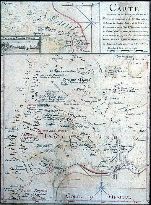
Carte Nouvelle de la Partie de l'Ouest de la Province de la Louisiane sur les Observations et decouvertes du Sieur Bernard de la Harpe - Commandant Sur la Riviere Rouge et ou paroissent ses Routes Colorées de Jaune et etablissement relatif à son Journal
Indian tribes; European exploration of western Lousiana; Jean-Baptiste Bénard de La Harpe; Red River; watercolor drawing, New Orleans; Louisiana waterways, Mississippi River
unidentified
This is a mid-nineteenth century manuscript copy of a 1720 map depicting depicting European exploration of western Louisiana.
Label copy from 1996 map exhibition:
In 1718 the Company of the Indies commissioned Jean-Baptiste Bénard de La harpe (c. 1683 - 1765) to establish a trading post on the Red River in Louisiana. He explored the river and started a fort west of Natchitoches, La. The following year La Harpe explored parts of the Arkansas River Valley and much of eastern Oklahoma. He accumulated valuable information from first-hand observations, questioning Indians and others, and from documents probably given to him by Jean Baptiste Le Moyne, Sieur de Bienville. After his return to France he wrote two histories of Louisiana which contain excellent commentary and descriptions of eighteenth century Louisiana.
This is a mid-nineteenth century manuscript copy of a 1720 map depicting depicting European exploration of western Louisiana. Includes images of "Cabannes Sauvages," [dwellings of the Indians at the Mississippi River delta].
In 1718 the Company of the Indies commissioned Jean-Baptiste Bénard de La harpe (c. 1683 - 1765) to establish a trading post on the Red River in Louisiana. He explored the river and started a fort west of Natchitoches, La. The following year La Harpe explored parts of the Arkansas River Valley and much of eastern Oklahoma. He accumulated valuable information from first-hand observations, questioning Indians and others, and from documents probably given to him by Jean Baptiste Le Moyne, Sieur de Bienville. After his return to France he wrote two histories of Louisiana which contain excellent commentary and descriptions of eighteenth century Louisiana. (c. 1683 - 1765) to establish a trading post on the Red River in Louisiana. He explored the river and started a fort west of Natchitoches, La. The following year La Harpe explored parts of the Arkansas River Valley and much of eastern Oklahoma. He accumulated valuable information from first-hand observations, questioning Indians and others, and from documents probably given to him by Jean Baptiste Le Moyne, Sieur de Bienville. After his return to France he wrote two histories of Louisiana which contain excellent commentary and descriptions of eighteenth century Louisiana.