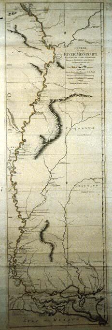
Course of the River Mississippi, from the Balise to Fort Chartres; Taken on an Expedition to the Illinois, in the latter end of the Year 1765
Sub-Title
Improved from the Surveys of that River made by the French
Subject
Mississippi River from Caskaskias [Kaskaskias] to the Gulf of Mexico; Milk Cliffs of Pointe Coupee, location of Indian villages, Fort la Boulaye ruins, St. Reine (abandoned), Carlstain, Fort St. Leon, Fort St. Marys
Date
1765 (historical)
Mapmaker
Ross, [John]
Publisher
Sayer, Robert
Place of Publication
London
Accession Number
XX0772
Curatorial Notes
Other copies, worse condition, T0055.1997.0459; 02124.
Exhibition History
Dec 1982-1984: map exhibition in Presbytere.
Notes
June 1, 1772 edition. Includes detailed instructions for navigating the river with landmarks along the banks. At the conclusion of the French and Indian War in 1763, England received the land east of the Mississippi River with the exception of New Orleans which passed into the hands of the Spanish along with the territory west of the Mississippi. Desiring information about their new territory, Britain sent an expedition to explore the area.
Size
44 x 13 1/2