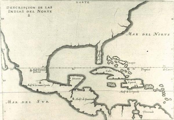
Descripçion de las Yndias del Norte [Description of the North Indies]
North America
[Herrera y Tordesillas, Antonio de]
[Madrid]
See Phillips, Vol. 1, p. 567, #1141. Label from 1996 exhibit: Many historians believe that one reason the continental interior of this map was left blank was because the Spanish government did not wish the geographical information supplied by early explorers and locations of their fortifications and settlements in thew New World to become known to foreign rivals. Other scholars believe that because Spain did not encourage colonization and trade in the New World at the time this map was published, there was no audience for a map delineating more than the barest amount of information. European mapmakers often depicted the New World as a virtually empty continent, thus perpetuating the myth of an empty frontier and ignoring the existence of indigenous peoples. The cartographers' actions thus encouraged a culture of conquest by using maps as instruments to seize Indian land.
Plate 1 frrom "Description de las Indias Ocidentales." Many historians believe that one reason the continental interior of this map was left blank was because the Spanish government did not wish the geographical information supplied by early explorers and locations of their fortifications and settlements in thew New World to become known to foreign rivals. Other scholars believe that because Spain did not encourage colonization and trade in the New World at the time this map was published, there was no audience for a map delineating more than the barest amount of information. European mapmakers often depicted the New World as a virtually empty continent, thus perpetuating the myth of an empty frontier and ignoring the existence of indigenous peoples. The cartographers' actions thus encouraged a culture of conquest by using maps as instruments to seize Indian land.