Grondvlakte van Nieuw Orleans de Hoofdstad van Louisiana [Plan of New Orleans, the Capitol of Louisiana]
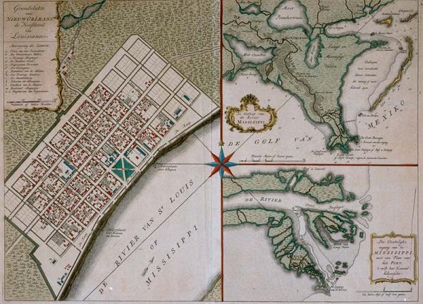
New Orleans; Mississippi River delta, location of buildings; Fort Balize
[Tirion, Isaac]
[Amsterdam]
See Phillips, Vol. 1, p. 345, #600. Other copies/versions (Dutch) located 02042; 1982.077.149; 1973.038.020. English edition located 09350.02. Label from 1996 exhibit: The "Fort that Commands the Channel" noted in the title of the lower right inset was Fort Balize (meaning buoy or beacon in French). Louisiana's first Spanish governor, Antonio de Ulloa (1716-1795), took possession of the new Spanish colony on January 20, 1767, at this site.
Plate 112 from Tiron's "Nieuwe en Beknopte Hand Atlas." The map of New Orleans was probably taken from Thomas Jeffreys map published 10 years earlier. A key identifies 13 structures. Fort la Balise [Balize] is located on the river delta map.