Kaart van Nieuw Vrankryk en van Louisiana Nieuwelyks Ontdekt [Map of New France and Louisiana, Newly Discovered]
Colonial Louisiana; Mississippi River; Louis Hennepin
unidentified
Other copies/editions located 09744.003, 02426, 1955.002.040, 1997.078.058, 1997.078.093; 1997.078.059, 1997.078.060.Label from 1996 exhibit: This Dutch adaptation of Hennepin's map features a title cartouche depicting the the triumph of Christianity in Louisiana. The coast of arms of the French House of Bourbon decorates the upper left.
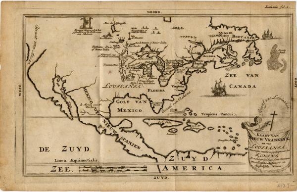
While René-Robert Cavelier de La Salle explored the lower Mississippi Valley, Louis Hennepin (1640-c.1705), a Recollect priest, traversed the Illinois River territory. He went west with La Salle, but was dispatched to the Illinois area to make friends with local Indian tribes. On his way, he investigated the Mississippi River. After living among the Indians for eight months, Hennepin returned to Paris. His 1683 book about the expedition, "Description de la Louisiana Nouvellement Découverte au Sud-Ouest de la Nouvelle France," included what is believed to be the first printed map, made from on-the-spot observations, bearing the name "Louisiane. Because he did not actually descend the Mississippi River to its delta, Hennepin depicted the river "Colbert" [Mississippi River] straight south and with a dotted line continued it to the Gulf at almost the same spot where the mouth empties into the Gulf of Mexico today. When his superiors ordered Hennepin to return to America, he refused and subsequently pledged his allegiance and dedicated a revised edition of his earlier work to King William III of England. In this version, Hennepin described himself as a leader of the expedition. He claimed he traveled the entire three-thousand-mile length of the Mississippi River in forty-seven days (to its mouth and back) two years before La Salle. To support his contention, Hennepin included a map depicting the entire course of the Mississippi River to the Gulf of Mexico. This work received great attention because its author urged William III, and thus England, rather than France, to colonize the Mississippi Valley. The British soon came to realize the economic and political potential of the vast territory described in Hennepin's work. The exaggerated and often fictional account of Hennepin's adventures was among the most widely read books of the period and was subsequently translated into several languages.
This Dutch edition of Hennepin's map features a title cartouche depicting the the triumph of Christianity in Louisiana. The coast of arms of the French House of Bourbon decorates the upper left.
While René-Robert Cavelier de La Salle explored the lower Mississippi Valley, Louis Hennepin (1640-c.1705), a Recollect priest, traversed the Illinois River territory. He went west with La Salle, but was dispatched to the Illinois area to make friends with local Indian tribes. On his way, he investigated the Mississippi River. After living among the Indians for eight months, Hennepin returned to Paris. His 1683 book about the expedition, "Description de la Louisiana Nouvellement Découverte au Sud-Ouest de la Nouvelle France," included what is believed to be the first printed map, made from on-the-spot observations, bearing the name "Louisiane. Because he did not actually descend the Mississippi River to its delta, Hennepin depicted the river "Colbert" [Mississippi River] straight south and with a dotted line continued it to the Gulf at almost the same spot where the mouth empties into the Gulf of Mexico today. When his superiors ordered Hennepin to return to America, he refused and subsequently pledged his allegiance and dedicated a revised edition of his earlier work to King William III of England. In this version, Hennepin described himself as a leader of the expedition. He claimed he traveled the entire three-thousand-mile length of the Mississippi River in forty-seven days (to its mouth and back) two years before La Salle. To support his contention, Hennepin included a map depicting the entire course of the Mississippi River to the Gulf of Mexico. This work received great attention because its author urged William III, and thus England, rather than France, to colonize the Mississippi Valley. The British soon came to realize the economic and political potential of the vast territory described in Hennepin's work. The exaggerated and often fictional account of Hennepin's adventures was among the most widely read books of the period and was subsequently translated into several languages.