Louisiana by de Rivier Missisippi (sic)
Colonial Louisiana, Mississippi River, Indian tribes
unidentified
unidentified
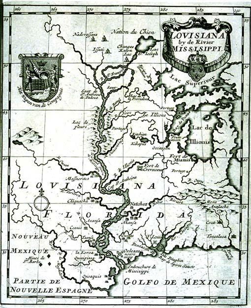
Second copy located 1997.078.012. Label from 1996 map exhibition: "Although the maker of this map is not identified, it is stylistically similar to those of Dutch mapmaker Herman Moll. The Great lakes are distorted and the Mississippi River's delta is misplaced. Many Indian tribes such as the Tensas, Cenis, Arkansas, Natchez, Houmas, Kikapoos, Quinapisa, And Koroa are located.
A cartouche in the upper left corner features the coat of arms of the Company of the West, which was granted control of Louisiana in 1717. The cornucopia from which water is flowing, a symbol of the Mississippi River, served as prototype for an image later incorporated into the great seal of the city of New Orleans. The crown above the cornucopia symbolized the royal sanction of the Company of the West; the Indians shown alongside the water are Brazilian, not Louisiana, natives.
Although the maker of this map is not identified, it is stylistically similar to those of Dutch mapmaker Herman Moll. The Great lakes are distorted and the Mississippi River's delta is misplaced. Many Indian tribes such as the Tensas, Cenis, Arkansas, Natchez, Houmas, Kikapoos, Quinapisa, and Koroa are located.
A cartouche in the upper left corner features the coat of arms of the Company of the West, which was granted control of Louisiana in 1717. The cornucopia from which water is flowing, a symbol of the Mississippi River, served as prototype for an image later incorporated into the great seal of the city of New Orleans. The crown above the cornucopia symbolized the royal sanction of the Company of the West; the Indians shown alongside the water are Brazilian, not Louisiana, natives.