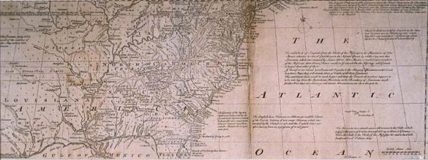
Map of the British and French Settlements in North America, A
Sub-Title
{Part the Second} containing Part of New York, Pensilvania (sic), New Jersey, Mary Land (sic), Virginia North & South Carolina[,] Georgia, Louisiana, and all the Countries Westward in the same Parallels so far as Discovered, shewing (sic) the Course of the Rivers Ohio, Missisipi (sic) &c. exhibiting the just Boundaries of the French Encroachments Laid down from Authentic Surveys
Subject
North America
Date
1755 c.
Mapmaker
Bowen, T[homas], engraver
Publisher
[Martin, Benjamin ?]
Place of Publication
[London]
Accession Number
T0007.1982
Curatorial Notes
Earlier catalog work sheets notes this was printed in "A General Magazine of Arts and Sciences," published by Benjamin Martin. Part of the "war of maps" waged by England and France during the first half of the 18c; this cartographic confrontation culminated with the French and Indian War (known as the Seven Years' War in Europe), which in turn ended with the expulsion of France from the North American continent. This particular map was Emanuel Bowen's response to Bellin's "Carte de la Louisiane et des Pays Voisins." It includes, in the upper left corner, a legend asserting that Vitginia and New England extend "from the Atlantic ocean to the South sea."
Exhibition History
1996 Sep - Mar 1998, So Much More than Just a Map Dec 1982-1984: map exhibition in Presbytere.
Size
8 1/4 x 19 1/8