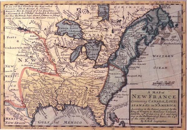
Map of New France Containig Canada, Lousiana &c. in N[or]th America
Sub-Title
According to the Patent granted by the King of France to Monsieur Crozat, dated the 14th of Sep[tember] 1712. N. SS and registered in the Parliament of Paris the 24th of the same Month
Subject
Colonial Louisiana, location of Indian tribes, North America, British colonies, location of mines, British vs. French names of Mississippi, Missouri, Wabash Rivers; Dauphin Island.
Date
[1711 - 1717]
Mapmaker
Moll, H[erman]
Publisher
[Nutt, J.]
Place of Publication
[London]
Accession Number
1980.065.001
Curatorial Notes
See Phillips, Vol. 1, #557, p.312.
Notes
From Moll's 1711-1717 "Atlas Geographus, " vol. 5, plate 676a. Includes notation by Moll that, "You will find Florida in this Map called Louisiana; The R. Misisipi[,] R. St. Louis; Massacre Port & Haven of ye Isl. Dauphine; le Missours R.[,] R. St. Philip; Ouabach R.[,] R. St. Jerom. For thus the French have altered ye Names in ye Kings Grant of those Countries to Monsieur Crozat."
Size
7 1/4 x 10 1/8