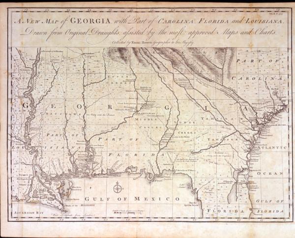
New Map of Georgia, with Part of Carolina, Florida and Louisiana, A.
Colonial Louisiana, Georgia, Carolina, Florida, southeastern United States, location of Indian tribes, trading paths, forts, settlements, Fort Rosalie, Natchez.
Harris, John
[London]
See Cummings, #267, p. 216. Important and detailed map of the Southeast. Second copy located 1997.078.032.
Plate II, p. 323, from John Harris's "Navigatium atque Itinerantium Bibliotheca. [A Complete Collection of Voyages and Travels]." This map, which grossly misplaces New Orleans, includes notations of those Indian tribes allied with France and those with Britain. It is also an example of the geopolitical nature of European mapping of the New World. Georgia, a British colony, extends from the Atlantic coast west of the Mississippi River. The legend placed at present-day Natchez, Miss., notes that the Natchez Indians were "Lately destroyed by the French." In November 1729, hundreds of Natchez warriors, angered over French encroachment of their fertile lands and increased demands for foodstuffs and furs, attacked Fort Rosalie, killing two hundred and thirty-seven men, women and children. During the Natchez War that followed the French nearly exterminated the Natchez and the Company of the Indies returned the colony to the French government.