New Map of the North Parts of America claimed by France, A
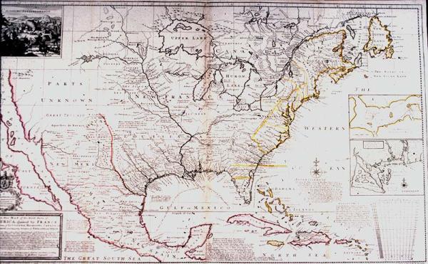
North America, Annapolis Royal Harbor, Mississippi and Mobile Rivers, Indian Fort Sasquesahanok (located on Susquehanna River, Pennsylvania). Cherokee, Iroquois, location of Indian tribes, boundary disputes between the France and Britain during the colonial period.
[Moll, Herman]
[London]
Sould be photographed. England's reply to Deslisle's 1718 map, reasserting British claims to land claimed by France in Deslisle's map.
Dedicated to Thomas Bromsall. Includes notation that much of this map was taken from maps made by Blackmore, Benisford, Capt. Nairn, and Deslisle's 1718 "Carte de la Louisiane, and that, "The French Divisions are inserted on purpose, that those Noblemen, Gentlemen, Merchants &c. who are interested in our Plantation in those Parts, may observe whether they agree with their Properties, or do not justly deserve ye name of Incroachments (sic); and this is ye more to be observed; because they do thereby Comprehend within their Limits ye Charakee [Cherokee] and Iroquois, by much ye most powerfull (sic) of all ye Neighbouring (sic) Indian Nations, the old Friends and Allies of the English, who ever esteemed them to be the Bulwark and Security of all their Plantations in North America."