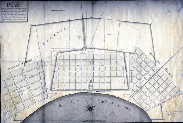
Plan dressé en éxécution de l'arrête du Conseil de Ville de la Nlle. Orleans, approuvé par le Maire le 15 Juin 1807 [Plan drawn in execution of the order of the Council of the City of New Orleans, approved by the Mayor June 15, 1807]
Sub-Title
relativement aux Six Cents Verges de terres communes, à partir des fortifications et sur toutes faces, sur lesquelles il à été reconnu à la dite ville un droit de propriété par les Etats Unis.
[relative to the six hundred rods of common lands, to start from the fortifications and on all sides by which a property right of the said city has been recognized by the United States.]
[relative to the six hundred rods of common lands, to start from the fortifications and on all sides by which a property right of the said city has been recognized by the United States.]
Subject
New Orleans, La.; Fauboug Marigny; Faubourg St. Marie [Fauboug St. Mary]
Date
1809 Apr 15 (historical)
Mapmaker
Tanesse, [James]
Place of Publication
[New Orleans, La.]
Accession Number
T0055.1997.0322
Curatorial Notes
Second copy located 1975.115.002.14
Notes
Handwritten note, bottom of map, "First map of the Fauxbourg Marigny made by Jean Tanesse for Bernard Marigny."
Media Type
negative photostat
Size
10 3/4 x 16 3/4