Plan du Port de la Nouvelle Orléans [Plan of the Port of New Orleans]
Sub-Title
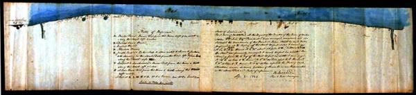
représentant
1. Les Sondes prises le 23 Juin de cette année en présence de Mrs. N. [?] [?] Cox et P. Rousseau composant le comité chargé par le Conseil de ville de faire un rapport sur la situation du Port, et sur les moyens de l'améliorer
[Soundings taken June 23 of this year in the presence of Messieurs N. [?], [?] Cox, and P. Rousseau comprising the committee charged by the city council to make a report of the situation of the port, and on the ways to improve it.]
2. Un projet de Wharfs ou Quais pour faliciter, aux eaux basses, le chargement et déchargement des Navires.
[A plan for wharves or quays in order to facilitate, a low water, the loading and unloading of ships.]
3. Un projet de redressement du Chemin Public depuis la rue Toulouse jusqu'au Faubourg Ste. Marie.
[A plan for straightening out the public road from Toulouse Street up to Faubourg St. Mary]
Subject
Port of New Orleans, Louisiana
Date
1823 Jun 27
Mapmaker
Pilié, [Gilbert] J[oseph]
Place of Publication
New Orleans, La.
Accession Number
1976.097
Curatorial Notes
Previously stored c1d1. See also 1997.001.021.04; T0055.1997.0367 for other editions.
Media Type
manuscript
Size
14 X 43