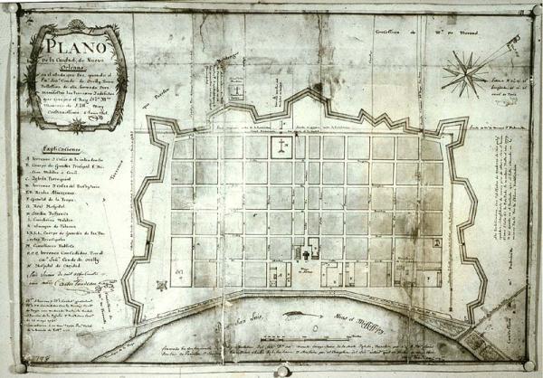
Plano de la Ciudad, de Nueva Orleans.
Sub-Title
en el estado que fue, q. Señr. Conde de O'Relly [O'Reilly], Tomo Possession de ella, formado Para manifestar los terrecos y edificios que compro el Rey Nro.[Mro.?] Monarco de S. Md. muy Cristianissima
Subject
Colonial New Orleans
Date
1801 May 2 (historical)
Mapmaker
Trudeau, Carlos
Place of Publication
[New Orleans, La.]
Accession Number
3798
Exhibition History
Dec 1982-1984: map exhibition in Presbytere.
Notes
This is a Jun 6, 1801 certified copy. This map shows how New Orleans commands the portage from the Mississippi River to the headwaters of Bayou St. John and thence by water to lake Pontchartrain. The portage is now known as Bayou Road. Canal Carondelet was later deepened and used for navigation. The turning basin can be seen below one of the towers of the wall. Several large plantations are depicted outside the city which was surrounded by cypress swamps.
Media Type
copied mss on board
Size
13 3/4 x 20 1/4