Regni Mexicani Seu Novæ Hispaniæ, Ludovicianæ, N. Angliæ, Carolinæ, Virginiæ et Pensylvaniæ, necnon Insularum Archipelagi Mexicani in America Septentrionali [Carefully Prepared Map of the Mexican Dominion or New Spain, Louisiana, New England, Carolina,
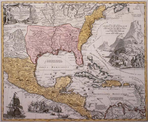
New Spain, Louisiana, New England, Carolina, Virginia, Pennsylvania, Islands of the Mexican archipelago in North America. Tobacco, sugar, animal skins, fish, ingots of precious metals, naval battle scene.
[Vieling, J. H. G.]
Nuremberg
Other copies located 1997.078.115, 1980.014.008. See Phillips, Vol. 1, p. 332, #586. 1996 exhibition label in "notes," above. Colored. Donor's notes: dramatic map showing French influence in Louisiana after the Treaty of Utrecht. Southern boundary of Carolina intrudes into Spanish regions in Florida. Has large amount of detail, place names, clearly delineated geo-political boundaries. After Deslisle's 1718 Carte de la Louisiane. Ross noted "Exceptionally decoratove map depicting North America from the Great Lakes to New Mexico and south to Panama and Venzuela and including all the West Indies. This is Homann's version of Deslisle's 1703 "Carte du Mexique et de la Floride." "
From "Atlas Novus Terrarum Orbis Imperia." Title cartouche (top left) replete with imagery representing New World wealth and products: tobacco, sugar, animal skins, fish. The foot of the seated male figure rests on ingots of precious metals. He holds a feather fan common to South American Indians. The nude female Indian holds a calumet while pointing to the title, here depicted on a buffalo hide. The center right cartouche shows Brazilian Indians gesturing toward a chest filed with trade goods or treasure being offered by European explorers. In the background, native workers, being directed by Europeans, are seen laboring to extract ore from the side of a hill. A naval battle scene adorns the bottom right.