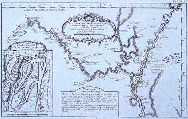
Suite du Cours du Fleuve St. Louis
Sub-Title
depuis la Riviere d'Iberville jusqua celle des Yasous et les Parties connues de la Riviere Rouge et la Riviere Noire
Subject
Course of the Mississippi River from Iberville River (now Iberville Bayou) north to junction of the Yazoo (Yasous) River; course of Red River from its junction with the Mississippi to Natchitoches and includes the course of the Black River. Location of Indian tribes. Includes remarks concerning a raft blocking the Red River and area flora and fauna (crocodiles [alligators], tigers, buffalo, deer, bears.) Image of Fort St. Jean at what became Natchitoches. Location of Adayes (Los Adaes). Mississippi River basin.
Date
[1764]
Mapmaker
Bellin, [Jacques Nicolas]
Publisher
Bellin, [Jacques Nicolas]
Place of Publication
[Paris]
Accession Number
1982.077.013
Alternate number
Seiferth Collection
Curatorial Notes
See Phillips, vol. 2, p. 348-362, #3508
Exhibition History
Dec 1982-1984: map exhibition in Presbytere.
Insets
Carte de l'Etablissement Francois sur la Riviere Rouge
Notes
Plate 46 from Bellin's "Le Petit Atlas Maritime," Vol. 1.
Size
8 1/2 x 13 1/2