View of the Harbour of the City of New - Orleans
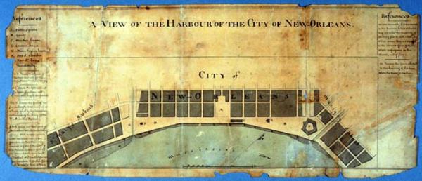
New Orleans riverfront, first 2 blocks from the Mississippi River, Faubourgs St. Mary and Marigny. Area along the riverfront reserved for steamboats, flatboats, barges, the "boats of peddlers," "butchers who supply the market," area reserved to U.S. Navy, appropriation of riverfront space by the military. Certified copy by James Tanesse, Aug[ustin] Macarty, mayor, and Mich[el] deArmas
New Olreans, La.
Second copy (photocopy) located T0055.1997.0332.
Delineates New Orleans riverfront, first 2 blocks from the Mississippi River, Faubourgs St. Mary and Marigny. Notes area along the riverfront reserved for steamboats, flatboats, barges, the "boats of pedlars," "butchers who supply the market," area reserved to U.S. Navy, and "the point which the military officers wish to appropriate to the exclusive use of the garrison," thereby leaving only 2,250 feet where vessels may load and unload "barely sufficient [to] accommodate 22 vessels" even though 500-600 vessels arrived anually in the Nw Orleans harbor. This caused incoming vessels to tie to eachother, thereby exposing the ships to the "ruinous effects of storms" and fires. Certified copy by James Tanesse, Aug[ustin] Macarty, mayor, and Mich[el] deArmas