World's Industrial and Cotton Centennial Exposition, New Orleans, La., U.S.A, The
Sub-Title
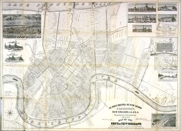
Department of Installation, Plan No. 2 Map of the City of New Orleans showing location of exposition grounds and all approaches thereto by land & water
Subject
1884 World's Industrial and Cotton Centennial Exposition, points of interest, buildings, hotels, New Orleans
Date
1884 (historical)
Mapmaker
Southern Lithograph Co.
Publisher
World's Industrial and Cotton Centennial Exposition
Place of Publication
New Olreans, La.
Accession Number
1976.093.005
Curatorial Notes
Other copies, some in very poor condition, located 0788B.013, 10844.002, T0055.1997.0359-364. Different edition located T0055.1997.0343-344.
Insets
1. Plan of New Orleans in 1770, by Capt[ai]n Pittman of the British Army 2. Rail Road Map of Louisiana and Texas 3. [South Pass lighthouse, Eadsport, La.]
Notes
Includes several visual insets: "Perspective view of the Building and Grounds from the Northeast," "Mexican National Headquarters," "Grand Rapids (Mich.) Furniture Pavillion," "United States and State Exhibits," "Art Gallery," "The Main Building," "Factories and Mills," "Horticultural Hall," "The Ground Plan," "View of New Orleans in 1719."
Media Type
pocket map
Size
26 1/2 x 37