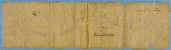
[Map of the River Washita from Bayou Tensas, La. to Hot Springs, Ark.]
Washita River; [Ouachita River] from Hot Springs to the confluence of the Red and Mississippi Rivers
Washington, D. C.
Label copy from 1982 exhibition, shown under section, "Later Exploration [of Louisiana]": Upon the transfer of the Louisiana Territory to the United States President Thomas Jefferson chose Captain Meriwether Lewis and Lt. William Clark to head an expedition to explore the area between the Mississippi and the Pacific. Several maps resulted which showed the extent and diversity of the vast land." ID label: "A Map of the River Washita [in Louisiana from the Hot Springs to the Confluence of the Red River with the Mississippi. Laid down from the journal and survey of William Dunbar in the year 1804.] by Nicholas King, in "Message from the President of the United States communicating discoveries made in exploring the Missouri, Red River and Washita, by Captains Lewis and Clark, Doctor Sibley, and Mr. Dunbar." Washington, 1806.
Nicely colored fleur de lis compass direction
From, " Message from the President of the United States communicating discoveries made in exploring the Missouri, Red River and Washita, by Captains Lewis and Clark, Doctor Sibley, and Mr. Dunbar." Washington, 1806.