Maps at the Louisiana Historical Center
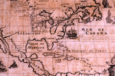
The Louisiana State Museum Historical Center cartographic holdings total 1,400 original maps and date from 1525-present. An additional 600 pieces are non-original works such as photostatic and photographic reproduction maps. The museum's cartographic collection contains many valuable maps concerning the exploration and settlement of Louisiana during the colonial period as well as maps delineating Louisiana and her cities and towns after the Louisiana Purchase, from 1803 to the present time. Other maps depict the Mississippi River, other Louisiana waterways, the Gulf of Mexico, the circum-Caribbean region, other states and cities, as well as parts of Canada, South America, Europe, and Africa. Several maps concern the Battle of New Orleans and the Civil War.
The cornerstone of the Historical Center Map Collection, is the Helen and Solis Seiferth Collection, which is made up of 159 Maps, (1541-1878), and five atlases, (1709-1848). It also includes works by noted cartographers Jacques Nicolas Bellin, the Bleau family, Father Louis Hennepin, Gerhard Mercator, and Abraham Ortelius. One of the most important maps in the Seiferth collection is Guillaume de L'Isle's 1718 "Carte de la Louisiane," which was printed in two editions. The Seiferth copy is a first edition print which does not locate New Orleans, established by Bienville in spring 1718. Once the French cartographer was advised of the newly-founded settlement (possibly fall 1718 or spring 1719) he altered the copperplate and continued printing this map. The museum's collection houses two copies of this altered version which includes what became known as the Crescent City.
Please click here to explore our maps database online.